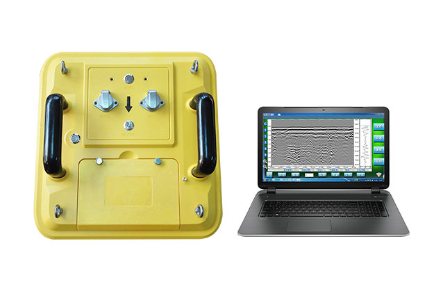
TS-WGR1201(A)Wireless Ground-penetrating Radar


    TS-WGR1201(A)The wireless ground-penetrating radar adopts the software controlled digital design centering on ultra-long pseudo-random coding mechanism and ultra-wide band sampling technology, realizing all the functions of common ground-penetrating radar, and delivering additional functions such as wireless transmission, hardware and software filtering, time varied gain, software delay, software adjustable sampling, standard IEEE802.11 communication protocol and automatic parameter setting. Meanwhile, the ground-penetrating radar developed by Tensense is the first system with wireless transmission function in the industry. It can use any device with WLAN function such as portable computer and tablet computer for display and storage, and work continuously for more than 14 hours.

  • Signal super detection
  • System stability
  • WiFi wireless
  • Battery long working
  • Advantage
  • Details
  • Performance
  • configuration
1

Meet the needs of municipal pipeline detection


The full digital design controlled by software is simple

to operate and convenient to use

2

100MHz~900MHz Standard antenna

Applicable to different application scenarios


It is used in shallow, engineering, municipal pipeline, environmental exploration, etc.Radar with appropriate frequency shall be selected according to different pipeline depth and pipe diameter.

3

Simple parameter setting

Gain adaptive adjustment

Main applicatio   

  • Engineering quality inspection;
  • Highway engineering quality inspection;
  • Hidden geological hazard detection;
  • Detection of underground concealed objects and facilities;
  • Underwater (fresh water) detection;
  • Life detection.

Advantage  

  • Ultra-strong weak signal detection ability;
  • A stable and reliable embedded operating system;
  • WIFI connection;
  • Long working hours of high power battery.

Technical feature 

Engineering quality inspection

  • Site backfill quality inspection
  • Quality evaluation of road and dam foundation projects
  • Foundation treatment effect detection
  • Construction quality inspection (inspection of wall cracks, cavities, reinforcement distribution, etc.)
  • Tunnel engineering quality inspection (tunnel primary lining and supporting thickness and secondary lining thickness, reinforcement distribution, etc.)

Detection of underground concealed objects and facilities

  • Underground pipeline detection
  • Underground air defense engineering detection
  • Detection of obstacles (large-diameter stones and concrete body) in pile foundation engineering
  • Archaeological exploration (using ground-penetrating radar to detect ancient tombs or sites such as ancient walls and roads)
  • Directional control and detection of inclined drilling and tunneling

Hidden geological hazard detection

  • Piping detection of embankments and dam foundations
  • Geological structure detection (fault, landslide contact surface, fold, unconformable contact, etc.)
  • Underground karst detection
  • Underground cavity detection of building foundations
  • Tunnel geological prediction

Highway engineering quality inspection

  • Construction stage quality inspection of highway engineering
  • Highway maintenance

Underwater (fresh water) detection

  • Water depth detection
  • Bottom silt and sediment thickness detection
  • Underwater riprap thickness detection

Geological exploration

  • Solving geological stratification, geological and environmental evaluation

Technical feature 

  • Integrated design, small size, light weight, low power consumption;
  • Able to run on multiple platforms such as Windows;
  • Real-time acquisition software TRadarSoft and data processing software TR are easy to operate and easy to use;
  • Large capacity hard disk access, easy to save.

Software functions

  • Reference value subtraction, filtering, north background processing, automatic gain setting, gain adjustment, echo alignment, automatic recognition layer, etc.;
  • εr (dielectric constant) and depth calculation;
  • Adjustment of the starting point of the depth coordinates;
  • Measurement of the depth of any two points.


--- Links ---

Address:Building 10, Fenghuang Industrial Park, No.52, Liufang Road, East Lake High-tech Development Zone,Wuhan

Sales:13545388336

After-sales:027-87921088

Maintenance:18627061330

QQ:2765677062

Copyright © 2024 Wuhan Tensense Geotech Prospecting Technology Co., Ltd.. All Rights Reserved 鄂ICP备13006517号-1